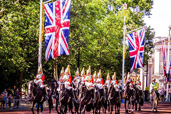
Start Your Travel Planning Here
Discover our Top Destinations
Discover our Top Destinations
2020 may be over, but the COVID-19 pandemic is far from it. While on one side we do have vaccines being administered to millions, on the other hand are looming issues such as the lack of enough quantity vaccines, the occurrence and severity of adverse reactions, and most of all, their durability against new coronavirus variants.
While mutations and variants are common for any pathogen (COVID-19 virus alone is said to have around 4000 of them), some in particular stand out and prove to be lethal as they circulate their way into the population. The United Kingdom (UK), as it turns out, happens to be one of the ‘origin areas’ of one of these variants. Discovered in November 2020, this particular variant has been estimated to have circulated in the country since as early as September 2020, and a high incidence of infections from it caused the UK to enter into yet another strict lockdown.
The lockdown, which is set to stay in place till at least March 2021, involves rules and regulations that are in many ways, stricter than the ones set on the onset of the first wave of COVID-19 in 2020. It has essentially put to an end the various relaxations that were being made for the foreseeable future.
Below we will find out the ways in which the ongoing pandemic and its recent developments have affected the state of travel for the UK.
The government has released its own list of countries from which arrivals are currently banned – no matter the circumstances. The only exception to this rule are British citizens and residents who wish to return to their home country.
At the onset of the previous lockdown, the rules for those entering the UK were pretty relaxed. While the country did close its border to international travelers, they allowed citizens and residents to return. Upon arrival, there was no testing or obligation to get quarantined. Of course, this soon changed with the rising numbers of incidence of the disease, whereupon, all arrivals were tested for the virus, but only those who tested positive were to go under mandatory quarantine.
The story of this lockdown, however, is very different. While the government has allowed need and importance-based arrivals into the UK from specific countries, the first thing they have to do is present a COVID-19 test result within 72 hours of arriving in the UK. They must also spend a mandatory period in hotel quarantine. This applied regardless of the status of citizenship and/or whether they test positive or negative for the virus.
The minimum period for quarantine is 10 days.
Unlike the former situation, traveling from the UK to other countries – be it for travel or business is a much tedious affair.
Unless the travel deals with the completion essential services (such as trade of food, medicines and other important supplies), acute emergencies (such as specific medical procedures), or high-priority diplomatic missions, traveling from the UK is completely prohibited.
The government has also put a law in place for lying. If residents leaving the country on an emergency basis are found to have lied about their international whereabouts, they face up to £10,000 in fines and/or up to 10 years in jail. This is unlike any of the other previous national lockdowns.
For UK residents, these developments come at the most unfortunate time. Given as most vacations happen during the summer (March to July), and bookings are done in advance, there are several doubts as to whether it is even sensible to book holidays (both domestic and international).
Even as vaccinations are being done at record speed (not to mention that the UK is the first country to come up with it in the first place), and the end of the current national lockdown being set in March, the uncertainty is at an all-time high. This is in no small part due to the fact that the death rate from COVID-19 is at an all-time high and that despite all measures, it has been extremely difficult to bring the number of daily new cases under control.
Throughout its history, air travel has maintained a record of changing with times and events. From technological advancements to the arrival of jet engine planes, to Transport Security Administration rules, and disasters such as the Hindenburg explosion and the more recent grounding of the Boeing 737 Max – several events have altered the way air travel works.
The COVID-19 epidemic is no exception to this. What had started out as a handful of novel corona-virus cases in December 2019 turned out to become a mass-scale global pandemic soon after, putting practically all of the world under lock down and essentially pausing all air travel. All for wait for a cure or a vaccine.
With over 10 months of the pandemic already passed, however, the world is moving on to adjusting to a new normal. With no vaccine or cure in sight still, both businesses, authorities and entities are now executing their operations in a way that best matches the current scenario.
Here are 5 ways in which the COVID-19 pandemic has changed the way air travel works:
As with most events, one can safely assume that new slew of rules and regulations will be here to stay, regardless where the novel corona-virus pandemic takes us.
The novel coronavirus is one of the world’s biggest health emergencies today. Officially called COVID-19, the disease, which originated from the city of Wuhan in China’s Hubei province, is now present in over 100 countries, having affected more than 1,00,000 people and claiming the lives of over 3,000 globally. Other than the fact that the disease spreads fast, not much is known about the its specifics.
Coupled with more events being cancelled and travel bans being imposed by the day, this has left many an international travelers in uncertainty. While many travelers are concerned as to whether they should suspend traveling or reap the benefits of wide-open award avail abilities, others are worried about their travel insurance status, and what their future would be should they have contracted the disease.
While only you can make the highly personal decision of continuing with or canceling your travel plans, here are some precautions you can take to minimize the chances of contracting COVID-19 when traveling as much as possible:
For most people, the opportunity to travel abroad is one of life’s greatest pleasures. Be it for a project, for business, or for leisure and vacation, traveling to a new country and immersing yourself in a new way of life can bring a lot of perspective. That being said, traveling abroad can be as much a nightmare as it can be a dream come true if you don’t have your process in place.
Traveling abroad is very exciting Here are some vital things to know before you embark on your out-of-country journey:
Knowledge is Power: It may sound boring and tedious but doing thorough research on your destination is one of the best and most rewarding things you can ever do. The reason is very obvious – while you know practically all there is to know about your home country, your knowledge on a foreign one is naturally next to none. Updating yourself on that allows you to know the essential things, which in turn helps you navigate your way when you reach there – both literally and figuratively.
Your Passport is Your Life: Without your passport, you will not even be allowed to go near an airplane. And without your passport in a foreign country, it will be very difficult for you to prove your identity, let alone citizenship. Always make sure that your passport is with you at all times and keep copies of it both at home (with someone you trust) and with you that you can easily use in case you happen to lose or misplace it.
If you don’t have insurance, you cannot afford to travel: Many consider insurance to be a fickle matter – the truth, however, couldn’t be farther than that. Health issues and calamities happen all the time, be it to you personally or in your destination at large. Having an insurance in place helps you be compensated for any troubles that you encounter that are beyond your control. In the event that you do have insurance, make sure it has all the adequate coverage.
Always Carry Prescriptions: Laws for medications vary from one country to another – for instance, a medicine that is available over-the-counter in your country, may not be available at all your destination country. Having a valid doctor’s prescription that lists all of your medications and vaccines makes the status of your medical needs, requirements and statuses legal. Additionally, it prevents you from running into any potential troubles that may arise due to differences in the availability of medicines.
Money Matters are Important: Apart from documents, money is the one pivoting aspect upon which the success (or failure) of your entire trip. As important it is to save on money, it is important to save the money you have from prying eyes and hands. Make sure you know about currency conversion rates, so that you can do your math and plan your expenditures accordingly. Next, make sure that your cards remain valid in the destination country – in the event that that is not the case, do get a card that does work. Try to make all your transactions in banks or ATMs instead of conversion centers, as they have a tendency to rip-off people in the name of conversion rates.
Traveling abroad is one of life’s best experiences, but it is also very labor-intensive. Not only do you need to spend an inordinate amount of time in having to pack (and unpack), you also need to ensure that you are complying to every rule and regulation out there.
Here is an international travel checklist that you can keep handy the next time you are planning for that international getaway:
When you are traveling, living out of your suitcase is pretty much the norm. Therefore, you must keep your bags and suitcase(s) extremely organized. Granted, it can be a challenge to keep a large variety of gear in what is essentially one box, but there are ways in which you can keep things organized without having to spend too much time and energy:
Personal care is very important when you are traveling. You must, therefore, have a compact, convenient and most importantly rule-compliant toiletry bag that can help you be at your personal best.
Ideally, your toiletry bag should have two sections, one for your personal items and another for medications and safety items.
The personal item section should have essential toiletries such as toothpaste and toothbrush, mouthwash, a comb and a hairbrush, clips and pins (if applicable), deodorant, conditioner and shampoo, sunscreen, face cleanser, moisturizer, a towel, basic makeup (if applicable), and personal hygiene items.
Beyond these, you should have a medicine bag where you can store your medications (i.e. if you are on any regular medications). Other than that, you should keep some general medicines that can be used in the event of a common (but not critical) issue such as cold, flu, fever, diarrhea, allergies, altitude sickness and the like. You must also include a mini-first aid kit complete with adhesives, gauze and bandages, a thermometer, an antibacterial ointment and a pest repellant. Remember – the goal here is to keep your health-related safety issues covered.
Having a carry-on bag is one of the most essential things you can ever have when on a trip abroad. This is primarily because airlines are known to misplace luggage. In the event that it does happen, your carry-on bag will ensure that you are not left stranded and can navigate your way in largely unfamiliar surroundings.
Your carry-on bag is meant to keep your most personal items, and by definition, should include your documents, personal gadgets (like mobiles, laptops, tablets and chargers), and basic toiletries. It is also wise to include an extra outfit (or two) that will prevent you from going through the hassle of rummaging through your luggage.
When traveling abroad, having all your documents in place is extremely essential. Without your documents (or even with incomplete documents), your ideal trip could turn into a bureaucratic nightmare. To prevent that from happening, make sure to maintain a travel document organizer complete with all essential documents.
The documents that you must always have by your side includes:
In most places, travelers tend to be the most vulnerable group, being prime targets for thieves and pickpockets. Other than being vigilant to keep your belonging safe and tight, you must keep yourself as safe and possible against miscreants whose activities will only serve to cause you unwanted trouble on your otherwise ideal trip. Here are some things you must do:
This may sound very redundant, but when you are going away for a trip abroad (especially for an extended amount to time), keeping and making sure that your home stays in order should be a priority. Here are some things you can do to make sure that your home does not go into disarray while you are gone:
Traveling is a beautiful thing – nothing is more enticing than being able to experience the way of life in of a new and unfamiliar place. Ask any frequent traveler and they will tell you that it is something you can never have enough of.
Frequent traveling, however, can be as tiring as it is rewarding – after all there are a lot of wear and tear and a fair amount of logistic skills involved in moving yourself (and your belongings) from place to place. Not to mention that things could go really awry should there be a hiccup within any of this.
When it comes to traveling, it is always better to be extra prepared. Here are some ways in which you can do exactly that, so that you can enjoy your trips without any hassles.
While this is one of the most boring aspects of any trip, packing well and ahead of time allows you to keep yourself from having to face the constant hassles of baggage-rummaging for every small thing just because you don’t know the place where things are kept.
The key to packing smart is to organize your most essential things in the most compact manner. The process, therefore, starts with making a list of all the items you need. Once you have that, you should organize them in a way that allows you to know exactly where things are kept so that you can access them with ease. Make sure that your baggage contain items that are travel-friendly, and that you are not carrying any fragile items that can break in transit.
Last but not the least, keep all your documents in once place, and make sure to have at least 2 copies that you can use in case of emergencies.
Most frequent travelers do not have the luxury of being able to book first class every single time. That said, there are ways to ensure that the airline travel experience does not turn into a recurring nightmare.
You can start by booking your flights in advance and through sites like Expedia and Kayak. Not only do such platform help you get the best value for money, they also help customize things like your layovers and help you get discounts on hotels. On the day of your flight, make sure to check in early to avoid having to stand in long queues. This also allows you to board your plane earlier, which in turn gives you the chance to choose your preferred option when it comes to seating.
Make sure that you know the baggage fee policy to avoid overspending or being forced to exclude luggage on the scene. Additionally, make sure to never keep your essential items in the luggage as they do often tend to get misplaced. Items like gadgets, money and documents must be kept in a carry-on bag that you must keep with you at all times.
Money is one of the most crucial things you need to have at hand when you are traveling frequently. The importance here is two-fold – you need to make sure that you spend your money wisely, and you need to make sure that you keep your money safe.
To keep your money safe, you must make sure to keep your wallet with you at all times. Additionally, you should also see to it that you have money stashed away in different places (like a secret pocket, a secret wallet, in-between your documents, etc.).
When it comes to travelling, having cashless sources are just as important – make sure you have a steady base of credit and debit cards. Make sure to keep them in a safe place and in a wallet that has RFID protection.
To save money, make sure that you keep your expenses in check and do not while away vital cash in any sort of temptations. To keep a cap on cash-spending, make sure to make use of loyalty cards, and avail services of hotels and establishments that can redeem loyalty points on those cards. This helps subsidize your charges.
When one is busy traveling from one place to another, things like fitness and/or beauty regime often take a hit. While it is not to bad to be ignored for small and infrequent trips, it can turn really counterproductive for frequent travelers if their health turns for the worst.
Create a compact beauty regime that suits you and yet is compliant with the rigors of traveling. Make sure to keep your cosmetics in small, break-proof bottles.
Plan your meals in advance so that you are not lost when it comes to menu items. Pick items that are both budget and health friendly – the last thing you want is to suffer an allergy from something you know nothing about. Last but not the least, always ensure that you are drinking plenty of water. It is, after all, one of the most vital fluids that and you must never be short of it.
While finding a gym is next to impossible, you can keep your exercise routine by incorporating workouts that can be performed anywhere in private (like in your hotel room) and use smart equipment like resistance bands. Just make sure that you have your running shoes with you.
Even if you’ve got everything planned and covered, there can (and will) always be times when things won’t go your way. Misunderstandings, misplaced goods, and other types of freak-outs can always happen for reasons beyond anyone’s control. Under such circumstances, always remember to smile and be in the present. After all, your trip is far too short to spend on being mad and bitter!
Being able to travel internationally is one of the best gifts of life – going to a foreign country and exploring the nitty-gritty of a new world opens your hearts and minds to new experiences that you never thought was possible.
Depending on your destination, traveling abroad can be a fairly simple to a very tedious affair. While some places function in a way that is similar to how things are being done at home, others can be totally different– and have very differing set of rules. In any case, a new country always means a new set of protocols that you must adhere to, and definitely don’t want to end up on the wrong side of.
Here are some tips that you should follow to keep your international travel experience as smooth as possible:
Having a clear and up-to-date passport is the most important thing you can ever have when it comes to international travel. Even the slightest blemish on your passport can mean a great deal of trouble that could potentially ruin your travel experience. Make sure that your passport has at least two blank pages, and that the expiry date is at least six months from the day you make your return trip. The latter especially is very important as many countries do not allow individuals with a less than six months expiry date on their passports to avoid having overstayers with no valid passport to return home to.
No matter how much you keep yourself and your surroundings safe, mishaps can – and do – happen. After all, all those horror stories told by overseas tour operators and travel agents do come from somewhere.
While there is no way to keep yourself absolutely safe from mis-happenings, it is possible to protect yourself in case of a calamity through sound and valid insurance plans. Insurance plans can protect you against a variety of unexpected events – from illnesses, accidents and thefts, to riots and disasters – having one ensures that you are properly compensated for your troubles. Make sure to opt for a policy that suits the nature of your travels and your personal needs and requirements.
Availability and legality of medicines vary from one country to another – what may be available in your country easily may not be available at all in another, or one that is available over-the-counter in your country may be a prescription-only drug in another.
In the event that you are on any regular medication – prescription or otherwise – make sure to have plenty of the medicines so that you don’t run short of it in the middle of your trip. Additionally, also make sure to have a copy of your doctor’s prescription (even for over-the-counter drugs) – so that in case you do have to buy medications abroad, you can do so without a hitch.
Regardless of whether or not you are on any medication, however, make sure to have some general medicines that can come in handy for common (but non-critical) medical issues such as common cold, flu, diarrhea. Also make sure to have general ointments for cuts and wounds.
With all the restrictions and regulations in place these days, traveling by-air can be a very tedious task. From booking to seating to packing – and everything in between – every aspect requires tact and care and special attention to the fact that you are not violating any rule. Dealing with such things can be difficult, and even the slightest of mistake can make things anywhere from uncomfortable to highly awry for you.
For starters, you must book your flight in advance with online travel sites such as Expedia or Kayak. Booking early reduces expense, while booking through online travel sites allows you to get the best deals available for your time and money and allow for discounted hotel bookings as well. Once you have booked your flight, make sure to research any airline restrictions for your carry-on baggage and luggage, so that you can pack your bags according to them (as opposed to going through the hassles of packing and unpacking in the security line).
When it comes to visiting a new city – getting lost is a real possibility – and something that happens way more often than one can think of. Always make sure you have enough information to be able to return to your hotel – or any other familiar spot.
Apart from having the most up-to-date version of maps on your mobile, make sure to have a decent printed map (this comes in handy especially when you are out of connectivity). A local map will also help you communicate with others easier in case you need to show someone (like a cab driver) where you would like to go. Besides that, make sure to grab a business card of the hotel you are staying at – it can help you find your way back in case you lose your way.
Additionally, check out the local tourist information office – it often has plenty of good ideas for getting around safely in your new surroundings, and also lists potential risks that you could benefit staying away from.
One of the worst faux pas you can ever make as a tourist is to dress in a way that is inappropriate to the local population. Every country has its own rules and customs of dressing and violating them only would only serve to bring unwanted attention to yourself. Make sure that your attire is suitable for the atmosphere you are visiting and does not make you stick out like an ‘obvious foreigner.’
While it is fun to have some spare change of a foreign currency to keep and show as souvenirs, having international money in larger amounts is nothing but a waste in your home country. This is because currency exchanges that buy foreign currencies in your home countries from you is something that is rare (if not impossible) to find.
The best thing to do is spend as much foreign currency as possible abroad, and in case you do not need any, make sure to exchange it before you board your return flight.
Traveling abroad is no easy task – more so when you are traveling for business. The general rigors of traveling aside, business trips require a greater deal of organization and coordination, given that ultimate objective is to have things work out in the best interest of your work and/or business.
Here is a handy checklist that explains the essential items that you must include on your packing list for a smooth, hassle-free business trip.
While this isn’t exactly an item by definition, doing proper research is extremely essential to keep your business trip smoot. When you are traveling from one country to another, it is very important to know all that is necessary about your destination, so that you do not run into any unnecessary problems that prevent you from reaching your objective.
Here are some things you must know in advance:
Having your documents in place – literally and figuratively is extremely essential when you are abroad. Without that, you may end up in varying degrees of trouble that may completely disrupt your trip and its very purpose.
The most important documents that you must keep in-check are:
In today’s day and age, when work is incomplete without the latest electronic gadgets and software. Here are the essential must-haves:
Given that conducting business is the intention of your trip, it is important to have some basic business-related equipment handy. Here are some of the things that you must definitely include:
Having your personal care products in place is an absolute must. Not only do they help you take care of your health best, they help you stay comfortable and save you from the hassle of having to buy and try out products during a time when you need to concentrate on your work and business.
Here are some must-have that you must include:
Purse and Wallet: Having a purse and wallet with essential items is a must. Must-haves for the purse include a pen and notepad, ID, breath mints and medications. Must have for the wallet include cash, ID and credit cards.
Clothes: Having the right clothes is important to maintain a good look whilst being comfortable. A good practice is to carry basic clothes that are comfortable and look good in formal situations. This includes a travel outfit (for traveling outside of the office) along with basic bottoms, a jacket or blazer, and tops/ blouses or sweaters (if applicable).
Cosmetics and toiletries: Your toiletries should include shampoo and conditioner, hairspray, face cleanser, toothbrush and toothpaste, a razor, and make-up. Make sure to pack them in a toiletry bag or a resealable plastic bag. Make sure to consider travel restrictions and keep the quantities of all liquids and gels within 3 ounces. Apart from these, make sure to pack a hand sanitizer, which can help you escape sticky situations.
Selecting a lawyer must not be a choice that is ignored, particularly because you are really putting your future in the hands of another person. To assist with that choice procedure, we spoke to Charlotte injury lawyers William H Harding Law to learn more, and there are particular requirements everybody needs to think about when searching for legal representation.
The value of knowledge in a lawyer can not be overemphasized. This is very important in cases that end up in lawsuits as you desire an attorney who has actually existed previously. Knowledge lawyers understand what techniques to utilize and when to utilize them. There is likewise a great deal of settlement that returns in forth in injury cases, so it is necessary to have the persistence to understand when to wait things out and when to have the decisiveness to settle. That all includes knowledge. Legal representatives who are knowledge in regional court systems likewise bring an included benefit, being so knowledgeable about topography.
When you discover yourself detained for a criminal offense, such as a DUI, you desire a criminal lawyer who concentrates on representing customers who deal with DUI charges. That sort of area of expertise enables customers to have the greatest opportunity of success. When you discover an attorney, who focuses on your kind of case, then it’s time to analyze their abilities. Interaction abilities are vital in a great attorney as you wish to work with a lawyer who can describe every information of your case so that you complete understand the whole of your circumstance.
It is essential to be able to contact your attorney when the circumstance requires it. Working with a injury lawyer Charlotte NC, who is strained with customers, suggests that you most likely will be restricted when it concerns any individually attention. Make certain that your legal representative is available and efficient in addressing your concerns when it’s essential. Lots of criminal cases and accident cases can present individuals to a fair bit of concern. Employing an attorney who is hardly ever readily available will just contribute to that concern.
Including a personal touch indicates taking an increased interest in every customer. That suggests including a little bit more care and attention to every case. Legal representatives who include that personal touch ended up being purchased their customers. While numerous attorneys have actually established a little a callous track record, those who offer a personal touch handle to make an enduring impression by revealing more listening and devotion.
The Law Offices of William H. Harding is all set to supply you with charlotte accident attorneys or a criminal defense attorney, who can fulfill all your legal requirements. Our group will go that additional mile to offer you with a top-notch mishap lawyer.
You Can Also Find William Harding Law At The Following Locations: www.williamhharding.com
Plastic surgery isn’t really simply for the abundant and popular any longer. Gone are the days when just stars and wealthy individuals would have unique access to these innovations that eventually made them look great and feel even much better about themselves.
Life-altering as they are, various plastic surgery charlotte treatments are carried out 1.6 million times annual. A research study performed by The American Academy of Facial Plastic and Reconstructive Surgery, Inc. exposed that surgical and non-surgical plastic surgery treatments are anticipated to continue to increase throughout 2015. Increased awareness, much better economy and an increased level of trust by customers are the most significant aspects for this increasing pattern.
Even as the market is taking pleasure in huge appeal amongst males and females, the concern stays: Exactly what encourages individuals to state yes to cosmetic surgery? The factors differ and, contrary to typical understanding, they definitely surpass vanity:
Individuals are constantly in pursuit of physical charm and vary considerably in exactly what they want as developments in plastic surgery allow us to accomplish those requirements in a reasonable and healthy method. Even individuals whom we believe have the best nose, eyes, lips, cheeks or chin can discover something incorrect in themselves and would desire to have actually something altered if they could.
An useful factor for going through facial surgery is to bring back one’s look following mishaps that trigger injury or significant physical modifications. For individuals who were born with genetic defects such as cleft lip and taste buds, extending or extremely big ears and other facial defects, plastic surgery can bring back both function and look. Occasionally this may even include Skinpen Microneedling services as well, make sure to ask your doctor for more information.
Health factors. In some cases, individuals are forced to go under the knife as an outcome of health problems. Individuals who have actually effectively fought versus skin cancer can turn to cosmetic and reconstructive treatments to restore their look and bring back their self-confidence.
With modern-day surgery innovations and modern devices, typical and unusual facial issues can be treated– however that’s not all there is to it. It is similarly essential to discover no less than the most certified cosmetic surgeon with competence and experience in the field.
In Charlotte NC Ballantyne Cosmetic surgery assures to offer clients professional care from the finest group of board-certified cosmetic surgeon and service technicians led by Thomas G. Liszka, MD. Given that 1993, Dr. Liszka has actually assisted numerous pleased clients accomplish their individual plastic surgeon objectives with his aid and care.
As a client, you have to recognize that delegating your face or body to the incorrect hands can have destructive impacts– as well as threaten your life! Find out more about Ballantyne Cosmetic surgery by checking out http://ballantyneplasticsurgery.com/ and have the comfort you should have as you choose to go under the knife.
If you live in North Carolina, then a bill recently passed into law by the N.C. Legislature might give you some relief from taxes. The bill was vetoed by Governor Roy Cooper, but the Legislature overrode his veto to pass the bill on June 28, 2017. The new law makes three beneficial changes to the State’s current tax code that you will want to be aware of as a resident of North Carolina. These three changes will become effective at the beginning of the 2019 year, except for the corporate income tax rate as stated below. The bill also set forth a budget plan and created an incentive program to bring new jobs to the state. If you or anyone you know should need advise on this new legislature please contact our office at Mcgrath & Spielberger; we also specialize in corporate and business contract law services.
The personal income tax rate will drop to 5.25% for a taxpayer’s North Carolina taxable income. The 2017 personal income tax rate is 5.499%.
The corporate income tax rate will drop to 3% for every C corporation doing business in the State, effective as of January 1, 2017. The corporate income tax rate will drop even further to 2.5% for taxable years beginning January 1, 2019. The current corporate income tax rate is 4%. New corporate tax rates may bring about a spring of new business in North Carolina. If you need any help with you Limited Liability Company registration and management services, this is also a service we can provide and have extensive experience with.
Additionally, each filing status will see an increase in the standard deduction.
Married, filing jointly/surviving spouse $20,000 (currently $17,500)
Head of Household $15,000 (currently $14,000)
Single $10,000 (currently $8,750)
Married, filing separately $10,000 (currently $8,750)
Kelly J. Brown is licensed to practice law in North Carolina, South Carolina, and U.S. Tax Court. Her areas of practice include business law, tax, real estate, and mortgage disputes. She also uses her Master’s in Tax Law and Master’s in Business Administration to assist her clients.
I have actually been in the web marketing field for 15 years and if there is something I have definitely learned, it is that you must follow two fundamental rules to be effectively marketing your business (or site) online. Online marketing is constantly progressing however these two staples will always stay strong.
Initially, we have to make our customers delighted. We need to offer them an easy way to access the information they are searching for whether looking for services they need or items they wish to buy. A website design has to work successfully on all available gadgets and platforms; including cellphones, tablets and PC along with browsers like Chrome, Internet Explorer & Firefox. With all the new technology in cordless interactions it is important for us to have our message plainly showed at all times.
The second rule we need to follow to be effective online is to keep Google pleased. I do not understand exactly what search engine your using but in accordance with searchenginewatch “Google holds a staggering 67.6 percent of the U.S. online search engine market share” and goes on to say that “Bing stayed a remote 2nd with 18.7 percent”. This, I think is put simply, Google brings back much better and more pertinent search engine result.
The leads online marketing charlotte nc personal opinion puts Google above all the competitors on practically every search. When using other engines, I always feel like the outcomes are not as customized to my searched keywords and phrases. Google has actually figured it out; they understand that if they keep users returning to them whenever they are looking for a product and services that they will continue to make over a billion dollars a week! That’s over 5 million dollars per hour in accordance with MOZ.
I often see people finding brand-new methods to rank at the top of the search engines using any methods possible. Here is the issue, you have some of the smartest people in the world working for Google, so much so they are making films about getting a job with Google!
They are generally called something adorable like panda, penguin, or hummingbird however will you still believe it is so charming when your website is punished? The majority of experts are now saying that if your site gets among these penalties you are better off starting over with a fresh URL and clean content. Every year you find out about a new animal signing up with the Google Zoo. My advice is to stay off the radar. If you are going to do your very own marketing then be sure you avoid the faster ways or use a trusted company.
Discover more about our services at https://leadsonlinemarketing.com/